


StreetWise CADlink 3.0 app for iPhone and iPad
Developer: Hangar 14 Solutions, LLC
First release : 19 Dec 2016
App size: 36.19 Mb
StreetWise CADlink provides serious, enterprise-grade software that is focused on providing MDC-style features for use in responding emergency apparatus. StreetWise is a hybrid of response software and preplan software, uniting these two traditionally distinct functions into a single platform. StreetWise is real software for departments that are serious about getting the most from tablets or replacing clunky outdated laptops.
This application includes a video demo of the full product. Full activation requires your department to have a subscription to StreetWise CADlink data services and a link to be setup with your dispatch system.
Features:
- Incident location and type are sent to assigned tablets with audible alert. Accuracy advisories provided if location is estimated.
- Incident updates sent by dispatch center instantly update on tablet display with pop-up advisory.
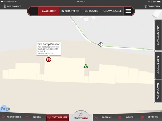
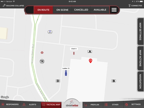
- Incidents are mapped automatically, with familiar “pinch-zoom” interface.
- AVL shows the location of other units in real time, see who’s on your call and who’s not.
- Tap-to-display data for other units shows apparatus type, pump and tank capacity, EMS level and staffing.
- Choices of icons and colors for various apparatus types, rotate in direction of travel.
- Web-based AVL display available for use at dispatch console or headquarters.
- Community hazards and preplan points are displayed graphically on the tactical map and can be shared with other agencies.
- Navigational routing is available, with turn-by-turn directions available.
- Hydrant layer shows location and touch-to-display data for water supply.
- Choices of icons for various types of hydrants or drafting points.
- Switch to satellite photo view or terrain view for enhanced situational awareness.
- Google StreetView is integrated for available interactive 360 degree photo.
- Tactical waypoints can be dropped on the map and instantly synchronized to all responding tablets for designation of staging areas, incident hazards, fire progression and more. NIMS icons available.
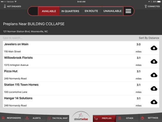
- Pre-incident plans are stored in the server and accessed on any responding tablet. Preplans can be shared with other agencies.
- Preplans can be selectively cached to device storage for use when no broadband is available.
- Exclusive “Preplan Wizard”, complete front-end pre-incident planning surveys for standalone business, master or tenant spaces allow field collection of preplans with the tablet.
- Preplan photos can be added right from the tablet during the survey. Additional attachments can be uploaded.
- New preplans are automatically synchronized to the server for immediate use by all devices.
- Instant photo “share” feature can send incident photos to other responding units or be used for post-disaster damage assessment. Photos are retrievable from administrative web portal.
- Device-to-group instant messaging. Message everyone or just the units on your call.
- Status buttons send instant timestamps to the server for later retrieval or sharing to CAD and NFIRS. All units’ current status displays to other responders.
- Live interface with Emergency Reporting® auto-creates NFIRS incident report, fills in unit times and tactical screen actions.
- Web-accessible agency log records every event and activity.
- Administrative web portal allows department to set icons, permissions, and entitlements for devices.
- Print, list, export, or import preplan data or finished preplans right from the web portal.
- CAD-independent, uses common data exports or optional dispatch workstation app.
- CAD transfers can use email, SMS, FTP, SFTP, XML, or a custom API.
- Basic, simple user interface with large, easy-to-read touch commands and limited menus.
- Bi-directional API interfaces available for sharing AVL and status buttons back to CAD systems.
Note: StreetWise uses location services, even when running in the background. Continued use of GPS running in the background can dramatically decrease battery life.